Even with the impending arrival of Hurricane Sandy we struck out on our journey. Our route took us along Route 360 West, Route 58, and Route 8.
Along the way, as my dad was out hunting turkeys elsewhere, we saw eight turkeys of our own in a field near the road. Passing through Basset, VA we watched a couple of fisherman out in the river fly fishing.
We reached our first destination, Jacks Creek Covered Bridge around 10:30.
 |
| Jacks Creek Covered Bridge |
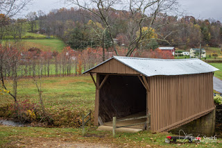
JACKS CREEK COVERED BRIDGE
The bridge was a little disappointing at first, as it is so close to the roadway that a guardrail had to be place virtually across part of the entry on one end. The bridge however, is extremely accessible and has multiple vantage point from which to shoot photos. One of the interesting aspects of the bridge can be found by taking a stroll through the bridge, inside there is graffiti from across the years the oldest (that we found) was a pair of initials carved and dated 1916.This 48-foot span bridge build of oak crosses the Smith River. It was constructed in 1914 by Charles Vaughan of the Buffalo Ridge area and designed by Walter Weaver of Woolwine. This historic landmark, a silent reminder to the past, has been bypassed by a modern bridge but has been preserved by the County for future generations
Back into the car and down the road only a little over 2 miles is the Bob White Covered Bridge. It is off the roadway and is tucked behind an old home.
 |
| Bob White Covered Bridge |
BOB WHITE COVERED BRIDGE
This 80-foot truss constructed over the Smith River was built in 1921. It served as a connection between Route 8 and Smith River Church of the Brethren on the south side of the Smith River. Bob White Covered Bridge, designed and constructed by Walter Weaver of Woolwine, served traffic for more than a half-century.
There were multiple places along the pathway and off to capture this beautiful covered bridge from multiple angles. The river here is seemingly very shallow. Walking across the bridge from the Route 8 side, as you come out the opposite end there are mountain rhododendron on the side of the hill. The odd angle that is now present at the exit to the bridge makes one wonder how any vehicle or wagon ever was able to pass through.
 |
| Privately Own Covered Bridge crossing the Smith River. |
From what we could tell about this particular bridge a barn door appears to have been added to the rear so that it is only able to be used as a bridge when the owners open it up. Behind the back of the bridge is a hay field.
 |
| Beautiful Fall Foliage near the Smith River. |
Having accomplished our mission of seeing the Covered Bridges we turned to exploring other places of interest in the area.
Fairy Stone State Park was along our route, we popped in for a brief stop and found out where we would be able to hunt for fairy stones. If we had been able to stay in the area it would have made a great afternoon excursion.
Back along the way we followed the signs to the A.L. Philpot Dam. It was a great side trip the overlook area provide a terrific view of Philpot Lake and Dam. From the observation area we were able to see the lake as well as the mountains in the distance. To view the dam we drove around to the base of the spillway. Another visitor to the area arrived and told us of a 8-point buck that had crossed his path as he came down the road.
Other things along the roadside that caught our interest were old buildings, the awe inspiring views, fall foliage - full of color, even some old vehicle - some rusty and ready for someone to find them and give them new life.
 |
| Waiting for a new occupant! |
Our final stop on the way back home was in Danville. I was specifically after a shot of the the mural honoring The Old No. 97. We did get the opportunity to go down to the river and shoot some photos of the bridges and falls.

No comments:
Post a Comment